Storms & Floods
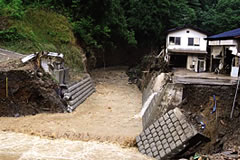 2008 Severe Rain (Nanto City)
Due to factors such as the effects of global warming, damaging heavy rain has become frequent throughout Japan in recent years. Toyama Prefecture has many fast-moving rivers, and it is especially important to be cautious of floods and landslides due to heavy rain. Overland flooding can also occur.
Severe Rain:
Small/Medium-sized Rivers Are Dangerous
Since localized severe rain occurs for only a short period of time and in an extremely limited area, it is difficult to predict the location, specific time, or amount of rainfall.
Furthermore, for rivers that are shorter and have a small basin area, the water level can increase suddenly and flood in the event of localized severe rain.
Landslides/Mudslides/Rockfall
When the land loosens from heavy or prolonged rainfall, landslides, rockfall, and mudslides are likely to occur. In mountainous regions of Toyama Prefecture, landslides can destroy houses, and damage to main roads can isolate towns.
Obtaining Weather Information
Check weather information and river conditions from meteorological observatories and Toyama Prefecture on TV, the radio, or the internet. Take proper precautions to minimize damage.
Be aware of advance warning signs, and evacuate promptly!
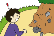
- Rockfalls
-
- You can see cracks in the cliff
- Water is gushing out of the cliff
- Pebbles are falling from the cliff
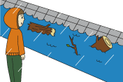
- Mudslides
-
- You hear rumbling from the mountains
- The river suddenly looks muddy and has driftwood
- The river water level decreases even though it continues to rain

- Landslides
-
- Water in wells and mountain streams becomes cloudy
- Cracks appear in the ground
- Water is gushing out of slopes
- Cracks appear in houses and retaining walls
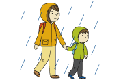
Points to Remember for Evacuating
Municipalities (cities/towns/villages) will announce evacuation information if disaster risk becomes high. Pay attention to information from TV, radio, internet, and the disaster public broadcast system.
Alert level 3 is "Senior citizens should evacuate" and alert level 4 is "Everyone should evacuate."
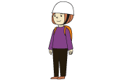
- Wear Comfortable Clothing
-
- If the wind is strong, wear a helmet or hard hat
- Only carry the essentials, and use a backpack so that both hands are free
- Wear sturdy shoes with thick soles (sandals and rain boots are dangerous)
- Wear sturdy shoes with thick soles (sandals and rain boots are dangerous)
- Avoid Acting Independently
-
- Evacuate as a family
- Assist elderly or disabled people
- Check on your neighbors, and help each other in walking to the designated evacuation area
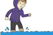
- Moving Through Flooded Areas
-
- If the road is submerged in more than 50cm (1 1/2 ft.) of water, do not force your way
- If the water is flowing fast, walking can be difficult at 20cm (8 in.) of water
- If there is danger of falling into ditches and such, be careful even with only 10cm (4 in.) of water
- If it is difficult to get to an evacuation area, do not force your way there. Instead, move to the second story of your house or other neighboring building.
Typhoons & Storms:

If a typhoon is approaching, gather information such as the typhoon's course and maximum wind speed using information provided by the Japan Meteorological Agency.
Being on the roads will put you in danger of flying debris and falling trees. Seek shelter in a nearby building. Close storm shutters and avoid going outside.
★How to check weather information on a mobile phone
"Toyama Bousai Web" mobile site (Japanese):http://www.bousai.pref.toyama.jp
Ministry of Land, Infrastructure, Transport and Tourism (MLIT) "River Disaster Prevention" (Japanese):
http://i.river.go.jp/